Frequently Asked Questions
1. What is Geo Insights about?
Geo Insights is a location intelligence tool designed for retailers, government bodies, and financial institutions to identify optimal locations for business expansion or policy deployment. Leveraging aggregated and anonymized data from Mastercard® and partners, it evaluates the success potential of specific categories in targeted areas.
By analysing sector-specific trends, Geo Insights highlights high-performing zones and uncovers untapped opportunities. It provides deep visibility into consumer behaviour, including spending patterns and foot traffic across key sectors such as dining, entertainment, transportation, and late-night retail—across both peak and off-peak hours.
2. Why and for whom did Mastercard create the Geo Insights tool?
Geo Insights was developed by Mastercard to support data-driven decision-making for retailers, government bodies, consulting firms, insurance providers, technology companies, and financial institutions. It enables users to identify high-potential locations for business expansion or policy implementation.
Whether it's a retailer launching a physical store or a city council evaluating the impact of initiatives – such as boosting the Nightlife economy – Geo Insights provides actionable intelligence through location-based analytics.
3. In what cities is the tool available and why not everywhere?
Geo Insights is currently available in Washington, D.C. Expansion to Ireland is planned in the near future, with broader market rollout targeted for 2025.
4. What do retailers or government councils gain from using the tool?
Retailers gain data-driven insights to evaluate the viability of expansion strategies at specific locations, leveraging aggregated and anonymized data from Mastercard® and partners—moving beyond intuition-based decisions.
Government councils benefit from spend and footfall analytics to inform policy-making, identify high-performing sectors, and uncover growth opportunities. Sector-specific trends and demographic insights enable targeted interventions to support local economic development.
5. How does the Geo Insights tool work?
Geo Insights uses responses to four simple questions to identify the most promising business types and locations, powered by aggregated and anonymized data from Mastercard®.
The tool supports city councils with actionable insights for:
- Zoning: Identifying optimal areas for new retail and entertainment hubs
- Licensing: Informing flexible licensing hours based on demand
- Transport Planning: Enhancing infrastructure during peak night-time economy (NTE) periods
- Safety: Allocating resources to high-traffic zones during night hours
- NTE Strategy: Guiding investments by evaluating market share and growth potential across sectors
6. What type of data does Mastercard process to power the Geo Insights tool?
Geo Insights is powered by aggregated and anonymized transaction data from Mastercard®, supplemented by insights from trusted third-party partners.
7. Is the opportunity assessment monetary value?
Geo Insights delivers a monetary evaluation of location-based opportunities using Mastercard® spend data and partner aggregators. Key metrics – including spend trends, forecasted growth, and advanced analytics – enable businesses to identify and act on high-potential areas for strategic expansion.
8. Can I compare different industries in the tool directly?
Yes, Geo Insights allows direct comparison across industries and regions using key metrics such as total spend, average transaction value (ATV), and other performance indicators—enabling informed benchmarking and evaluation.
9. I can’t find a specific business category or city in the dropdown menu. What now?
If a specific business category or city is not listed in the dropdown, we recommend using the tool with the available options and providing accurate responses to receive tailored insights.
Geo Insights currently includes merchant transactions in Washington, D.C., with Ireland as the next target location. All geo-locations are added in accordance with compliance policies.
For deeper market insights or support with specific categories, please contact the Mastercard® team.
10. Is it possible to change my answer in the form/quiz?
Yes, you can revisit the quiz and update your responses to generate new results. Upon completion, the tool redirects to the Heat Map landing page, where you can adjust filters such as time frames, industries, and visitor types – automatically updating the insights displayed.
11. Can I save my results?
Yes, you can save the results in the form of the csv file for later.
12. On what devices can I use the Geo Insights tool?
Geo Insights is accessible across all devices – including desktops, tablets, and smartphones – and is fully optimized for both Android and iOS platforms.
13. Does the website collect the data I submit?
Geo Insights processes your IP address and cookies in accordance with Mastercard®’s Cookie Policy.
14. What kind of consumer behaviour does "Geo Insights" track?
Geo Insights tracks consumer spending and foot traffic across key sectors such as dining, entertainment, transportation, and late-night shopping – during both peak and off-peak hours.
It also provides detailed metrics including : Top visitor country share, Spend share by day of the week, Active vs. inactive customer spend, Demographic segments, Online vs. offline spend share, Credit vs. debit spend share and Top origin ZIP codes.
15. How can this solution help identify opportunities in the city?
Geo Insights analyzes sector-specific and time-based trends to highlight high-performing zones, uncover underdeveloped areas, and identify growth opportunities based on real consumer behavior.
Each location is assigned a performance score, and the Night-Time Economy Volatility Index offers a dynamic view of emerging hotspots and fluctuations within the night-time economy.
16. How does this data support strategic planning and policymaking?
Geo Insights empowers city councils with data-driven insights to inform strategic decisions. The tool enables:
- Consumer Behaviour Analysis: Tracks spending and footfall across sectors like dining, entertainment, transportation, and late-night shopping during peak and off-peak hours.
- Opportunity Identification: Highlights high-performing zones and uncovers untapped areas based on demographic and sector-specific trends.
- Targeted Planning: Provides granular insights into customer segments – age, income, visitor origin – to guide localized strategies.
- Policy Development: Supports decisions on zoning, licensing reforms, transport planning, and safety initiatives, especially within the night-time economy.
- Performance Scoring: Each area is assigned a score, complemented by the Night-Time Economy Volatility Index to track dynamic growth and emerging hotspots.
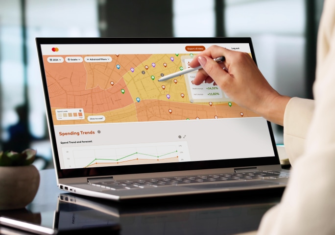
17. Is the data presented in a technical format? Will non-technical users understand it?
Geo Insights presents data through intuitive dashboards, heatmaps, and trend charts—designed for non-technical users such as city council staff and policymakers.
Results can also be exported as CSV files for further analysis or data modeling.
18. How accurate and updated is the data?
Geo Insights data is regularly refreshed to reflect real-time changes. Robust aggregation methods ensure high accuracy across all data sources.
Do you need more info?
Looking to find out more about how the tool can help you gain real local insights and plan successful policy? Want to know how the data can be filtered and optimized to your specific needs? Get in touch with our team and we’ll talk you through all the details.
Contact us